Le Morne Brabant
Le Morne Brabant
A basalt massif listed as UNESCO World Heritage, white sand beach and world-class kitesurfing spot: Le Morne Brabant combines nature, history and water sports at the southwestern tip of Mauritius.
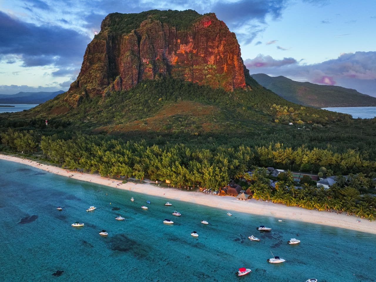
Le Morne Brabant is a basalt massif rising 556 metres that juts into the Indian Ocean at the southwestern tip of Mauritius. Inscribed as a UNESCO World Heritage Site in 2008, it owes this recognition to its tragic history: in the 18th and 19th centuries, escaped slaves sought refuge there to escape their masters. The peninsula also offers turquoise lagoons, kitesurfing spots among Africa's most renowned, and hiking trails leading to exceptional panoramic views.
Essential Practical Information
- Summit access: guided hike is mandatory — local guides gather at the base of the massif.
- Recommended duration: 3 to 4 hours for the round-trip ascent; allow an extra half-day for the beach and surroundings.
- Attire: hiking boots essential, the trail is rocky and steep.
- Accessibility: the summit is not accessible to people with reduced mobility; the beach and lagoon are accessible.
- Transport: car rental recommended; the peninsula is approximately 50 km southwest of Port-Louis.
What to See
The massif overlooks a peninsula bordered by a lagoon protected by a coral reef. On the seaward side, Le Morne beach stretches for several hundred metres, with shallow waters ideal for swimming. The site is world-renowned for kitesurfing and windsurfing: the southeast trade wind and the lagoon's configuration create technical conditions sought after by international competitors.
Along the massif's slopes, endemic vegetation alternates with sheer rock faces. At the summit, views embrace the southwestern coast, surrounding islets and, on clear days, the silhouette of Rodrigues Island on the horizon.
History and Context
Le Morne Brabant is inseparable from the history of slavery in Mauritius. Under French and later British colonial rule, runaway slaves — maroons who had fled the plantations — found refuge in the caves and inaccessible cliffs of the massif. According to oral tradition, on the day slavery was abolished in 1835, a group of enslaved people sheltering there, spotting British soldiers climbing the mountain, believed arrest was imminent and threw themselves into the void. The UNESCO inscription recognises this place as a symbol of the resistance of enslaved peoples in the Indian Ocean.
Highlights of Your Visit
The Guided Ascent
The trail departs from the base of the massif and climbs via rocky passages that are sometimes vertiginous. Local guides know the site's history and comment on endemic flora along the way. The final stretch, nearly vertical, requires good physical ability.
The Lagoon and Le Morne Beach
The beach is one of Mauritius's longest. The shallow lagoon, with its turquoise and emerald hues, is perfect for swimming and snorkeling. Kitesurfing schools offer lessons for all levels.
The Underwater Sand Dune
In calm conditions and from the heights or a boat, you can distinguish a cascade of white sand plunging into the depths offshore from the peninsula, creating the optical illusion of an underwater waterfall. This phenomenon is visible from the air or by boat.
Photography Tips
Morning light is ideal for photographing the massif from the beach: the rising sun illuminates the eastern face of the rock without backlighting. Late afternoon golden light on the lagoon is particularly flattering. From the summit, panoramic views are clearest before 10 a.m., before heat haze veils the horizon. Drones are subject to Mauritian regulations — verify authorisations before flying.
Location and Access
Le Morne Brabant is located at the tip of the peninsula of the same name, in the Black River district, at Mauritius's southwestern corner. The coastal B9 road runs along the peninsula from Case Noyale to the north. The nearest town with services is Black River (Rivière Noire), about fifteen kilometres away. Port-Louis is approximately 50 km distant. There is no direct public transport to the peninsula; car rental or taxi remain the most practical options.
In the Area
- Black River Gorges National Park — Mauritius's largest protected natural area, with forest trails and endemic species such as the Mauritius kestrel.
- Chamarel — hilltop village renowned for its Seven Coloured Earths and waterfall, roughly thirty kilometres to the northeast.
- Flic en Flac — long white sand beach with developed accommodation and dining options, on the west coast.
- Case Noyale — small fishing village north of the peninsula, departure point for boat excursions to the southwestern islets.
Frequently asked questions
Yes, the ascent must be done with an approved local guide. Guides are present at the base of the massif and know the safe passages as well as the site's history.
The dry season, from May to November, offers the most favourable conditions for hiking and summit visibility. The austral summer (December-April) can bring rain and cyclonic winds that make the ascent inadvisable.
The beach and lagoon are perfect for families. The ascent of the massif, however, involves steep passages and is not recommended for young children or people without sufficient physical fitness.
Several kitesurfing schools operate on Le Morne beach and offer beginner lessons. The lagoon, however, is renowned for its technical conditions; beginners must absolutely enrol at an organised school.
A full day allows you to combine the ascent in the morning, the beach in early afternoon, then a detour to Chamarel or the Black River Gorges in late afternoon. Car rental is essential for this itinerary.
Drone use in Mauritius is subject to strict national regulations and requires prior authorisation. Check with the Aviation Civil Authority of Mauritius before your visit.
Want to discover this destination?
Our local advisors design your tailor-made trip.